


Key Takeaways
- Offshore wind (land to sea) cleans up waves; onshore (sea to land) destroys them. Under 10 knots offshore is ideal.
- Offshore holds up wave lips for cleaner breaks; onshore collapses them. Even 5 knots offshore helps, while 8-10 knots onshore ruins a session.
- Check wind before swell. Target early morning for offshore. If onshore all day, try a break facing a different direction.
The Short Answer
Offshore wind blows from land to sea, holding up wave faces and creating clean, organized lines at breaks like Rincon and Malibu. Onshore wind blows sea to land, pushing waves down and adding chop. Most breaks measured by NDBC anemometers surf best with under 10 knots of offshore wind. Dawn patrol exists because overnight land cooling creates natural offshore flow that reverses by midday.
How Wind Direction Changes Wave Shape
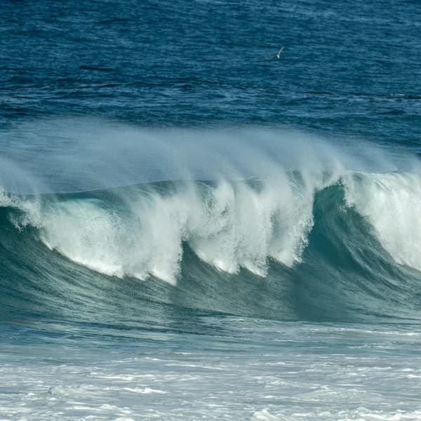
Offshore wind pushes against the wave face as it steepens, slowing the break and holding the lip up longer. This creates cleaner, more hollow waves with defined shoulders — ideal for surfing. Even 5 knots of offshore can transform a mushy wave into a rideable one. At 15-20 knots offshore, spray blows back over the crest (the classic "offshore mist" shot), but paddling out becomes difficult and drops are harder because the wind pushes you up the face.
Onshore wind does the opposite: it pushes the wave forward, collapsing the lip before it can form a clean face. Waves break inconsistently with no defined shoulder. The surface gets choppy, making it hard to paddle, hard to read the wave, and hard to generate speed. Even 8-10 knots onshore can ruin an otherwise solid swell. Cross-shore wind (blowing parallel to the beach) is in between — not ideal but surfable.
How Wind Direction Changes Wave Shape
Offshore holds up wave lips for cleaner breaks; onshore collapses them. Even 5 knots offshore helps, while 8-10 knots onshore ruins a session.
What This Means for Your Session
Check wind forecast before swell forecast — wind determines whether a good swell produces good waves. On Quiver, the wind overlay shows speed and direction for every 3-hour window. Target the early morning slot (5:30-9 AM) when thermal offshore is strongest. If your forecast shows onshore by 10 AM, be in the water by 7. If it's onshore all day, check a different break that faces the opposite direction — one beach's onshore is another's cross-shore or sideshore. Headlands and points can create localized wind shadows even when the regional wind is onshore.